Aksum (Axum)
The ruins of the ancient city of Aksum are found close to Ethiopia’s northern border. They mark the location of the heart of ancient Ethiopia, when the Kingdom of Aksum was the most powerful state between the Eastern Roman Empire and Persia. The massive ruins, dating from between the 1st and the 13th century A.D, include monolithic obelisks, giant stele, royal tombs and the ruins of ancient castles. Long after its political decline in the 10 th century, Ethiopian emperors continued to be crowned in Aksum.
Situated in the highlands of northern Ethiopia, Aksum symbolizes the wealth and importance of the civilization of the ancient Aksumite kingdom, which lasted from the 1st to the 8 th centuries AD. The kingdom was at the crossroads of the three continents: Africa, Arabia and the Greco-Roman World, and was the most powerful state between the Eastern Roman Empire and Persia. In command of the ivory trade with Sudan, its fleets controlled the Red Sea trade through the port of Adulis and the inland routes of north eastern Africa.
The ruins of the ancient Aksumite Civilization covered a wide area in the Tigray Plateau. The most impressive monuments are the monolithic obelisks, royal tombs and the palace ruins dating to the 6th and 7th centuries AD.
Several steles survive in the town of Aksum dating between the 3rd and 4th centuries AD. The largest standing obelisk rises to a height of over 23 meters and is equally carved to represent a nine-storey building of the Aksumites. It stands at the entrance of the main stele area. The largest obelisk of some 33 meters long lies where it fell, perhaps during the process of erection. It is possibly the largest monolithic stele that ancient human beings ever attempted to erect.
A series of inscriptions on stone tablets have proved to be of immense importance to historians of the ancient world. Some of them include trilingual texts in Greek, Sabaean and Ge’ez (Classical Ethiopian), inscribed by King Ezana in the 4th century AD.
The introduction of Christianity in the 4th century AD resulted in the building of churches, such as Saint Mary of Zion, rebuilt in the Gondarian period, in the 17th century AD, which is believed to hold the Ark of the Covenant.
Fasil Ghebbi, Gondar
In the 16th and 17th centuries, the fortress-city of Fasil Ghebbi was the residence of the Ethiopian emperor Fasilides and his successors. Surrounded by a 900 meter long wall, the city contains palaces, churches, monasteries and unique public and private buildings marked by Hindu and Arab influences, subsequently transformed by the Baroque style brought to Gondar by the Jesuit missionaries.
Fasil Ghebbi is located in the Amhara National Regional State, in the North Gondar Administrative Zone of the Federal Democratic Republic of Ethiopia. The serial property consists of eight components. Within the Fasil Ghebbi palace compound are: the Castle of Emperor Fasilides, the Castle of Emperor Iyasu, the Library of Yohannes; the Chancellery of Yohannes; the Castle of Emperor David, the Palace of Mentiwab and Banqueting Hall of the Emperor Bekaffa. The remaining seven components are located in and around the city of Gondar: the Debre Berhan Selassie (Monastery and church); the Bath of Fasilidas; Kiddush Yohannes; Qusquam (Monastery and Church); Thermal Area; the Sosinios (also known as Maryam Ghemb); the Gorgora (Monastery and Church) and the Palace of Guzara.
Between the 16th and 17th centuries, Ethiopian rulers moved their royal camps frequently. King Fasil (Fasilidas) settled in Gondar and established it as a permanent capital in 1636. Before its decline in the late 18th century, the royal court had developed from a camp into a fortified compound called Fasil Ghebbi, consisting of 6 major building complexes and other secondary buildings, surrounded by a wall 900 metres long, with 12 entrances and 3 bridges.
The fortress city functioned as the centre of the Ethiopian government until 1864. It has some twenty palaces, royal buildings, highly decorated churches, monasteries and unique public and private buildings, transformed by the Baroque style brought to Gondar by the Jesuit missionaries. The main castle has huge towers and looming battlemented walls, resembling a piece of medieval Europe changed to Ethiopia. Beyond the limits of the city to the north-west by the Qaha River, there is a two-storey pavilion of a bathing palace associated with Emperor Fasilidas. The building is a two-storey battlemented structure situated within and on one side of a rectangular pool of water which was supplied by a canal from the nearby river. The bathing pavilion itself stands on pier arches, and contains several rooms reached by a stone bridge, part of which could be raised for defence. Subsequent rulers, such as Iyasu the Great, continued building, improving the techniques and architectural style and expanded to the hills north-west of the city centre, in the area known as Qusquam.
Fasil Ghebbi and the other remains in Gondar city demonstrate a remarkable interface between internal and external cultures, with cultural elements related to Ethiopian Orthodox Church, Ethiopian Jews and Muslims. This relationship is expressed not only through the architecture of the sites but also through the handicrafts, painting, literature and music that flourished in the 16th and 16th centuries.
After its decline in the 19th century, the city of Gondar continued to be an important commercial and transport hub for northwest Ethiopia. Some of the monuments still retain their original spiritual function and the surrounding landscape has significant cultural importance for the local inhabitants.
Harar Jugol, the Fortified Historic Town
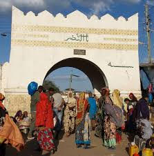
The fortified historic town of Harar is located in the eastern part of the country on a plateau with deep gorges surrounded by deserts and savannah. The walls surrounding this sacred Muslim city were built between the 13th and 16th centuries. Harar Jugol, said to be the fourth holiest city of Islam, numbers 82 mosques, three of which date from the 10th century, and 102 shrines, but the town houses with their exceptional interior design constitute the most spectacular part of Harar’s cultural heritage. The impact of African and Islamic traditions on the development of the town’s building types and urban layout make for its particular character and uniqueness.
The fortified historic town of Harar is located in the eastern part of Ethiopia, 525 km from the capital of Addis Ababa, on a plateau with deep gorges surrounded by deserts and savannah. The walls surrounding this sacred city, considered “the fourth holy city” of Islam, were built between the 13th and 16th centuries and served as a protective barrier. There were five historic gates, which corresponded to the main roads to the town and also served to divide the city into five neighbourhoods, but this division is not functional anymore. The Harar gate, from where the main streets lead to the centre, is of recent construction.
Harar Jugol numbers 82 mosques, three of which date from the 10th century, 102 shrines and a number of traditional, Indian and combined townhouses with unique interior designs, which constitute a spectacular part of Harar’s cultural heritage. The African and Islamic traditions influenced over a long period of time the development of the city and its typical urban planning and contributed to its particular character and uniqueness. The present urban layout follows the 16th century design for an Islamic town with its central core occupied with commercial and religious buildings and a maze of narrow streets with imposing facades. The traditional Harari house has a typical, specific and original architectural form, different from the domestic layout usually known in Muslim countries, although reminiscent of the coastal Arab architecture, and with an exceptional interior design. At the end of the 19th century Indian merchants built new houses with wooden verandas that defined a different urban landscape and influenced the construction of the combined Indian/Harari houses. Their architectural and ornamental qualities are now part of the Harari cultural heritage.
Harar functioned as the capital of the Harari Kingdom from 1520 to 1568, became an independent emirate in the 17th century and was integrated into Ethiopia in 1887. From the late 16th century to the 19th century Harar was an important trade centre between the coast and the interior highlands and a location for Islamic learning.
Today Harar is the administrative capital of the Harari People National Regional State . The historic town has a traditionally functioning community, forming a complex social-environmental whole where each element has its symbolic and practical significance. The Harari people are distinguished by the continued cultural traditions and quality of their handicrafts, including weaving, basket making and book binding. The organization of the communities through traditional systems has preserved its social and physical inheritance and, significantly, the Harari language.
Konso Cultural Landscape
Konso Cultural Landscape is a 55km2 arid property of stone walled terraces and fortified settlements in the Konso highlands of Ethiopia. It constitutes a spectacular example of a living cultural tradition stretching back 21 generations (more than 400 years) adapted to its dry hostile environment. The landscape demonstrates the shared values, social cohesion and engineering knowledge of its communities. The site also features wooden statues – grouped to represent respected members of their communities and particularly heroic events – which are an exceptional living testimony to funerary traditions that are on the road of disappearing. Stone steleas in the towns express a complex system of marking the passing of generations of leaders.
The Konso Cultural Landscape is characterized by extensive dry stone terraces bearing witness to the persistent human struggle to use and support the hard, dry and rocky environment. The terraces retain the soil from erosion,collect a maximum of water, discharge the excess, and create terraced fields that are used for agriculture. The terraces are the main features of the Konso landscape and the hills are contoured with the dry stone walls, which at places reach up to 5 meters in height.
The walled towns and settlements of the Konso Cultural Landscape are located on high plains or hill summits selected for their strategic and defensive advantage. These towns are circled by between one and six rounds of dry stone defensive walls, built of locally available rock. The cultural spaces inside the walled towns, called Moras, retain an important and central role in the life of the Konso. Some walled towns have as many as 17 Moras. The tradition of erecting generation marking stones called Daga-Hela, quarried, transported and erected through a ritual process, makes the Konso one of the last not comparable people.
The traditional forests are used as burial places for ritual leaders and for medicinal purposes. Wooden statues (Waka), carved out of hard wood and mimicking the dead, are erected as grave markers. Water reservoirs (Harda) located in or near these forests, are communally built and are, like the terraces, maintained by very specific communal social and cultural practices.
Lower Valley of the Awash
The Awash valley contains one of the most important groupings of paleontological sites on the African continent. The remains found at the site, the oldest of which date back at least 4 million years, provide evidence of human evolution which has modified our conception of the history of humankind. The most spectacular discovery came in 1974, when 52 fragments of a skeleton enabled the famous Lucy (Dinknesh)to be reconstructed.
The Lower Awash Valley paleo-anthropological site is located 300 km northeast of Addis Ababa, in the west of the Afar Depression. It covers an area of around 150 km2.
Excavations by an international team of palaeontologists and pre-historians began in 1973, and continued annually until 1976, and ended in 1980. In that time, they found a large quantity of fossilised hominid and animal bones in a remarkable state of preservation, the most ancient of which were at least four million years old. In 1974, the valley produced the most complete set of remains of a hominid skeleton, Australopithecus Afarensis, nicknamed ‘Lucy’, dating back 3.2 million years. Afarensis has since been proved to be the ancestral origin for both the Genus Australopithecus and Homo-sapiens.
A recovered female skeleton nicknamed ‘Ardi’ is 4.4 million years old, some 1.2 million years older than the skeleton of Australopithecus afarensis ‘Lucy’.
There is a wealth of Paleo-anthropological and prehistoric tools still awaiting discovery and scientific study and these are seen as constituting an exceptionally important cultural heritage resource.
Lower Omo Valley
A prehistoric site near Lake Turkana, the lower valley of the Omo is renowned the world over. The discovery of many fossils there, especially Homo gracilis, has been of fundamental importance in the study of human evolution.
The Lower Valley of the Omo is located in south-western Ethiopia. It extends over an area of 165 km2. The age-old sedimentary deposits in the Lower Omo Valley are now world renowned for the discovery of many hominid fossils that have been of fundamental importance in the study of human evolution.
The Lower Omo Valley includes the Konso and Fejej paleontological research locations with sedimentary deposits going back to the plio-pleistocene period. These have produced numerous hominid and animal fossils, including fragments of Australopithecus. The deposits of human vertebrae fauna, and paleo-environmental evolution, shed light on the earliest stages of the origins and development of Homo sapiens of Africa. The discoveries of ancient stone tools in a campsite also offers evidence of the oldest known technical activities of prehistoric beings, thus making the property one of the most significant for mankind.
Since 1966, scientific research has proved that the site significantly contributes to prominent archaeological, geological, paleo-anthropological and paleo-environmental studies.
Rock Hewn Churches of Lalibela
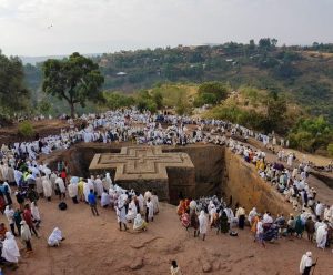
The 11 medieval monolithic cave churches of this 13th-century ‘New Jerusalem’ are situated in a mountainous region in the heart of Ethiopia near a traditional village with circular-shaped dwellings. Lalibela is a high place of Ethiopian Christianity, still today a place of pilgrimage and devotion.
In a mountainous region in the heart of Ethiopia, some 645 km from Addis Ababa, eleven medieval monolithic churches were carved out of rock. Their building is attributed to King Lalibela who set out to construct in the 12th century a ‘New Jerusalem’, after Muslim conquests terminated Christian pilgrimages to the holy Land. Lalibela flourished after the decline of the Aksum Empire.
There are two main groups of churches – to the north of the river Jordan: Biete Medhani Alem (House of the Saviour of the World), Biete Mariam (House of Mary), Biete Maskal (House of the Cross), Biete Denagel (House of Virgins), Biete Golgotha Mikael (House of Golgotha Mikael); and to the south of the river, Biete Amanuel (House of Emmanuel), Biete Qeddus Mercoreus (House of St. Mercoreos), Biete Abba Libanos (House of Abbot Libanos), Biete Gabriel Raphael (House of Gabriel Raphael), and Biete Lehem (House of Holy Bread). The eleventh church, Biete Ghiorgis (House of St. George), is isolated from the others, but connected by a system of trenches.
The churches were not constructed in a traditional way but rather were hewn from the living rock of monolithic blocks. These blocks were further chiselled out, forming doors, windows, columns, various floors, roofs etc. This gigantic work was further completed with an extensive system of drainage ditches, trenches and ceremonial passages, some with openings to hermit caves and an underground system of tunnels.
Biete Medhani Alem, with its five corridors , is believed to be the largest monolithic church in the world, while Biete Ghiorgis has a remarkable cruciform plan. Most were probably used as churches from the outset, but Biete Mercoreos and Biete Gabriel Rafael may formerly have been royal residences. Several of the interiors are decorated with mural paintings.
Near the churches, the village of Lalibela has two storey round houses, constructed of local red stone, and known as the Lasta Tukuls. These exceptional churches have been the focus of pilgrimage for Coptic Christians since the 12th century.
Tiya Archeological Site
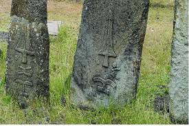
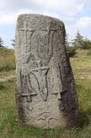
Tiya is among the most important of the roughly 160 archaeological sites discovered so far in the Soddo region, south of Addis Ababa. The site contains 36 monuments, including 32 carved stelae covered with symbols. They are the remains of an ancient Ethiopian culture whose age has not yet been precisely determined.
The stelae from the Soddo region, with their mysterious configuration, are highly representative of an expression of the Ethiopian megalithic period.
Soddo lies to the south of Addis Ababa, beyond the Aouache river. It is remarkable because of the numerous archaeological sites of the megalithic period, comprising hundreds of sculptured stelae, that have been discovered there. The carved monoliths vary in size from 1 m to 5 m. Their forms fall into several distinct categories: figurative composition; anthropomorphic; hemispherical or conical; simple monoliths. In the northern area are to be found stelae with depictions of swords, associated with mysterious symbols and schematic human figures.
Among the most important of the roughly 160 archaeological sites discovered so far in the Soddo region is Tiya, lying 38 km south of the river, which is also one of the most representative. Roughly aligned over an axis of 45 m there is a group of 33 stelae, with another group of three stelae a short distance from them. Of the 36 stelae at Tiya, 32 are sculpted with vaguely representational configurations (including the sword designs) . One depicts the outline of a human figure in low relief.
They are the remains of an ancient Ethiopian culture the age of which has not yet been precisely determined. However, they have been interpreted as having a funerary significance, as there are tombs scattered around the stelae.


